
The CDC Walking Trails programme caught our attention because it combines two things many of us already enjoy: exploring Singapore and getting rewarded for it. With CDC vouchers to be earned along the way, it felt like a good reason to turn an ordinary walk into something a little more interesting.
After finishing the Kampong Glam CDC Walking Trail, we decided to take on the Central Singapore CDC Walking Trail next. Being one of the original trails in the programme, it was a nice way to discover another part of Singapore while getting some steps in.
In this article, I’ll share what the trail is about, what to expect along the route, and a few practical tips to help you plan your walk.
What is the CDC Walking Trail?
The CDC Walking Trail is an initiative by GovTech Singapore and the five Community Development Councils (CDCs), designed to encourage people to be more active while discovering different neighbourhoods around Singapore.
There are currently 10 trails in total, covering various parts of the island. 5 of the trails are original trails launched in 2025, and 5 of them are Heritage Trails launched in 2026.
By completing a trail, eligible participants can earn CDC vouchers, subject to reward availability. Here are the rewards you can get:
- $5 in CDC vouchers for completing the trail (once fully-redeemed, it’s gone and won’t be replenished)
- $5 for finding all the mystery Ollies in the original trails; or $10 for Heritage trails (replenished every start of the month)
To complete the trail, you need to visit every checkpoint, take photos of the landmarks, and answer a question at each stop. If you also want the extra Ollie reward, you will need to locate all the mystery Ollies along the way.
And at time of writing, the CDC vouchers for completing the Central Singapore Trail has been fully redeemed. This won’t be replenished.
Since the Central Singapore trail is one of the original trails, the reward for finding all the Ollies is $5, not $10. This CDC vouchers will be replenished every start of the month.
Before starting, it is worth checking whether the rewards are still available, as redemptions are limited and may run out.
The vouchers are awarded per person rather than per household. This means that if you complete the trail with your spouse, both of you can earn the CDC vouchers individually. Do note that these rewards are only available to Singapore Citizens and Permanent Residents.
Central Singapore CDC Walking Trail: Route Overview
Have any questions about traveling in Singapore? Join All About Singapore Travel FB group, I'll be there to answer your questions!
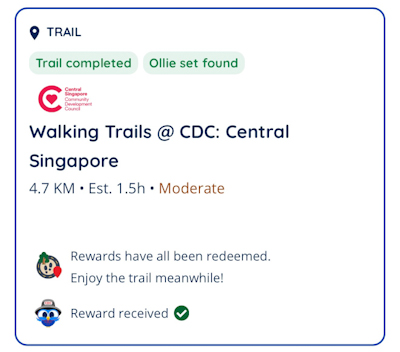
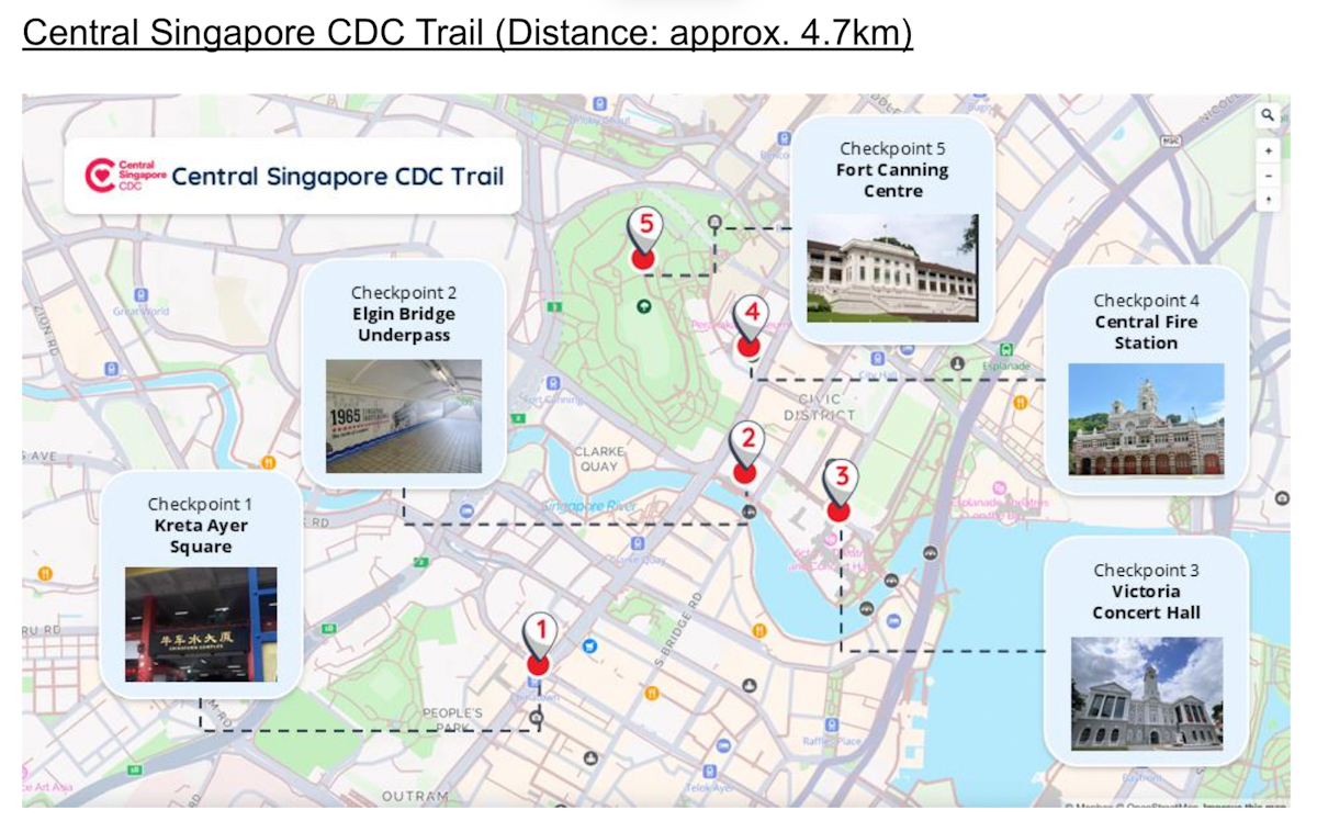
The Central Singapore CDC Walking Trail covers a distance of about 4.7 km and the estimated duration is around 1 hour 30 minutes.
The trail starts at Kreta Ayer Square which is right at the heart of Chinatown and ends at Fort Canning Park. The nearest MRT stations to reach the starting point are Maxwell Station (TEL) and Chinatown Station (NEL).
We spent about 2 hours to complete the trail because we did the trail with a toddler and we made a detour at Chinatown Point to buy drinks and ice cream.
Central Singapore CDC Walking Trail: Checkpoints & Map
The 5 checkpoints on Central Singapore CDC Walking Trail are:
- Kreta Ayer Square
- Elgin Bridge Underpass
- Victoria Concert Hall
- Central Fire Station
- Fort Canning Centre
And the distance between checkpoints are as follows:
- CP1 (Kreta Ayer Square ) to CP2 (Elgin Bridge Underpass) = 1.5 km
- CP2 (Elgin Bridge Underpass) to CP3 (Victoria Concert Hall) = 450m
- CP3 (Victoria Concert Hall) to CP4 (Central Fire Station) = 1.25 km
- CP4 (Central Fire Station) to CP5 (Fort Canning Centre) = 500m
Below is the interactive Google Map that I created for this trail. It includes the checkpoint, my suggested routes as well as places along/nearby the route where you can take a break, grab food/drink or go to toilet.
As this is an urban trail, there are many possible ways to get from one checkpoint to another, so there is no need to follow my suggested route exactly. The checkpoints are fixed, but the route itself is flexible. A good rule of thumb is to head towards where Ollie is, as that will usually be the most practical route.
Food, Drinks and Toilets Along the Way
Based on our experience, here are places along this Central Singapore CDC Wallking Trail to find food, drinks or toilets:
- Before starting the trail: Maxwell Food Centre, Chinatown Complex Food Centre
- Between CP1-CP2: Chinatown Point, The Central at Clarke Quay
- Between CP2-CP3: no shopping malls, only museum and restaurants along Singapore River
- Between CP3-CP4: Funan, Raffles City Shopping Centre
- Between CP4-CP5: no malls along the way
- After completing the trail: there are restaurants and toilets at Fort Canning Centre
How to Get to Kreta Ayer Square
So, the starting point of this Central Singapore CDC Walking Trail is Kreta Ayer Square. It is within walking distance from Maxwell MRT Station (TEL) and Chinatown MRT Station (NEL).
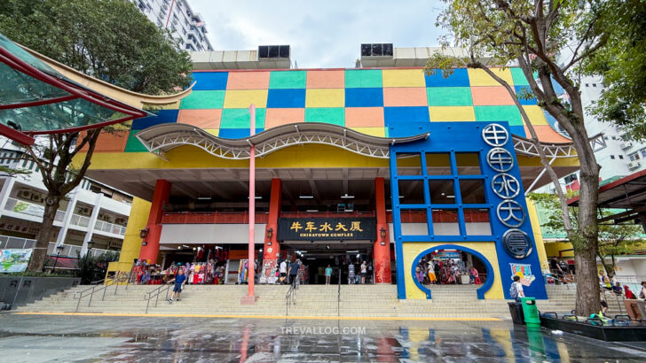
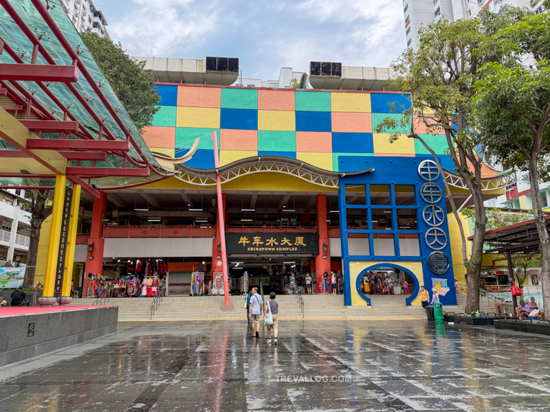
The photo be taken is the signboard of Chinatown Complex as shown in the above photo. If you’re thinking to eat before starting the trail, there are 2 hawker centres nearby: Chinatown Complex Food Centre and Maxwell Food Centre.
If you’re looking for aircon food options, you can head to Buddha Tooth Relic Temple and go to Basement, there is a vegetarian food court. Otherwise, there are tons of restaurants at the Chinatown street market.
CP1 (Kreta Ayer Square) to CP2 (Elgin Bridge Underpass)
The first section of the trail is about 1.5km long. From Kreta Ayer Square, you need to walk through the Chinatown Street Market and get yourself to New Bridge Road.
Then, walk along New Bridge Road towards Clarke Quay. Along the way, you will walk past Chinatown Point which has a supermarket (Fairprice) and tons of restaurants.
When you arrive at Singapore River, on your right, you can see an underpass. Just follow the ramp and go under the bridge. Be careful though, there are usually many cyclists going at high speed at this underpass.
The photo you need to take is the mural on the wall at the underpass. The murals depict the past and present of Singapore.
CP2 (Elgin Bridge Underpass) to CP3 (Victoria Concert Hall)
The distance between Elgin Bridge Underpass and Victoria Concert Hall is quite short, at about 450m. From the underpass, walk towards Asian Civilisation Museum and then turn left and you will find Victoria Concert Hall.
Victoria Concert Hall is quite huge. The side you need to take the photo from is right next to the Empress Place green field, facing The Merlion and Marina Bay Sands.
CP3 (Victoria Concert Hall) to CP4 (Central Fire Station)
The next section is between Victoria Concert Hall and Central Fire Station. This distance of this trail varies by the route that you take.
If you aren’t chasing any Ollies, you can just walk straight along Parliament Place/High Street until you reach Hill Street. Then, cross the road and you will arrive at Central Fire Station. Total distance is about 700m.
However, if you are chasing Ollies, you might need to take longer routes, depending on where the Ollies are. At time of writing, to chase Ollies, you need to walk along St Andrew Road, Stamford Road and then Hill Street. And the total distance is about 1.25km.
CP4 (Central Fire Station) to CP5 (Fort Canning Centre)
The final stretch is from Central Fire Station to Fort Canning Centre. Even though it is quite a short distance at about 500m, it is the most tricky section in my opinion.
From Central Fire Station, you turn to Coleman Street and walk past Children’s Museum. Then, walk further up the hill and enter the Fort Canning area.
The area within Fort Canning has lots of stairs and not that wheelchair-friendly. After you passed by Spice Garden, there are 2 main trails to choose from.
The first trail before the cemetery wall goes to Artisan’s Garden and Keramat Sultan Iskandar Shah. You do not want to take this one. Take the other trail after the cemetery wall which goes through the green field of Fort Canning Green.
After reaching the Cupolas (round-shaped pavilion), you need to climb up the stairs to reach the Fort Canning Centre and check-in to the last checkpoint.
Other CDC Trails:
Kampong Glam – CDC Waking Trail
Read more:
Things to do in Chinatown, Singapore
Complete Guide to Fort Canning Park
If you like my work, you can buy me a coffee! Your support will help me to keep going!